Research interests and future directions
Interested in coming to work with me as a student or post-doc? Please get in touch! Current and near-future research directions include:
- Controls on sediment size and soil production in mountain landscapes
- Climatic signals in weathering, erosion, and landscape change
- Interactions between biota and rocks/soil, particular in weathering and soil production
- Geochemical signatures of wildfire in soils
- Applications of tracer thermochronology, cosmogenic nuclides, bulk geochemistry, and/or numerical modeling in surface processes: if you have an idea, let’s talk!
Current and recent projects
Microbial ecology and soil production in recently deglaciated landscapes
Collaborators: Michael Beman, Michal Ben-Israel
This project examines the role of microbiota in soil production and rock weathering at a landscape scale in catchments in the Eastern Sierra Nevada. Stay tuned for results!
Biogeochemical signals of wildfire in the Sierra Nevada
Collaborators: Hannah Palmer, Sora Kim, Asmeret Berhe
Wildfires impact soils in many ways, depending on the severity of the fire and other local conditions (vegetation, hillslope steepness, etc.) This work focuses on constraining biogeochemical changes in soils across a range of burn severity from fires that burned in 2021 in the Western Sierra Nevada, which have implications for nutrient fluxes in soil and water, and post-fire soil recovery.
Soil production and weathering in New Zealand
Collaborators: Kevin Norton, Tony Dosseto, Georgina King, Dennis Dahms
Soil production should be limited by rates of chemical weathering and erosion. Recent work has proposed a “speed limit” for soil production in rapidly eroding mountains, where erosion removes material before it has much chance to weather (Dixon and von Blankenburg, 2012). Soil production rates on the west coast of New Zealand’s Southern Alps appear to exceed that speed limit by an order of magnitude (Larsen et al., 2014). These sites are uplifting rapidly, and experience one of the wettest climates on Earth.
These observations raise a host of interesting questions about how this landscape is evolving, and about the broader interactions between climate, tectonics, and Earth’s surface. What sets the “speed limit” for soil production in this landscape, if one exists at all? How do climate and tectonics affect chemical weathering and soil production?
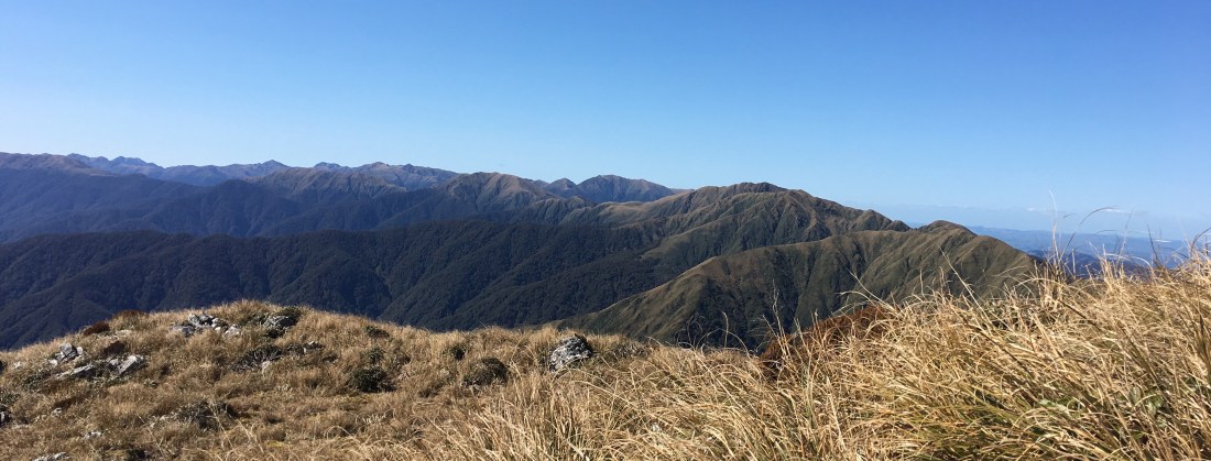
Tararua Range, N. Island NZ
Saprolite weathering and soil production along a climate gradient: Tararua Range (N. Island NZ)
This work combines bulk geochemistry and cosmogenic nuclides to quantify chemical weathering and soil production rates across a kilometer of relief in the Tararuas. This site provides a great contrast to S. Island sites, where uplift is much faster. In the Tararuas, saprolite weathering shows trends with altitude and climate, and plays an important role in the total chemical flux from the landscape.
Catchment-averaged denudation and weathering in the Dobson River catchment (Southern Alps, NZ)
Master’s student Maia Bellingham recently handed in her thesis (congratulations, Maia!) on the Dobson catchment. Her thesis included catchment-average denudation rates from a series of catchments measured using cosmogenic nuclides. She also assessed the intensity of chemical weathering on hill slopes, and the implications of weathering and erosion for long-term sedimentation and chemical fluxes into Lake Ōhau.
Biological controls on weathering in NZ
PhD candidate Eron Raines is examining possible biological contributions to weathering in the Tararuas (N. Island) and the Southern Alps. This collaborative project includes a host of methods, including U-series chronometry in soils, radiocarbon, and biochemical metrics. Eron’s primary supervisors are Kevin Norton (VUW Geography), Tony Dosetto (Wollongong, Aus.), and Julie DeSlippe (VUW Biology).
Geochemical constraints on tephra inputs to soils in New Zealand’s Wairarapa region
Collaborator: Kevin Norton
This project uses geochemistry in soils and bedrock to evaluate the intensity of chemical weathering, soil production, and erosion across hillslopes. In these soils, geochemistry suggests a significant input of volcanic tephra, which was deposited during Holocene eruptions of the Taupo Volcanic Center. Using a forward model, we show that tephra constitutes roughly 40% of the total mass of soils, and likely provides most of the nutrients available to biota. Using geochemical data and cosmogenic nuclides, we have reconstructed a landscape history over the past ~27,000 years that includes tephra deposition, soil development and mixing, and rapid soil stripping associated with human arrival in NZ (Lukens and Norton, 2021, AGU special issue).
Spatial variations in sediment size inferred from detrital thermochronology
Collaborators: Cliff Riebe, Leonard Sklar, David Shuster
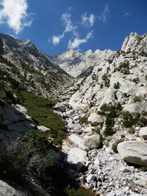
Inyo Creek, eastern Sierra Nevada
Sediment produced on mountain slopes is an important part of many surface processes. It influences rates of bedrock river incision and impacts fluvial habitats. Sediment also reflects the processes that erode the landscape, from rockfall to soil creep. Understanding how sediment size varies across a landscape is important for a range of geomorphic, hydrologic, and ecologic problems (Sklar et al., 2016).
This work constrains spatial variability in the sizes of sediment produced on hillslopes. I used detrital thermochronometry in sediment of many different sizes to trace each sediment clast back to its origins on the landscape. This allowed me to quantify how sediment size distributions change across a steep mountain landscape. This variability in sediment size likely reflect both topography and climate (Riebe et al., 2015), and each sediment size tells a different story about sediment origins and transformation during transport (Lukens et al., 2023)
Grain-size bias in detrital studies
Collaborators: Cliff Riebe, Leonard Sklar, David Shuster
Spatial variability in the sizes of sediment produced on hillslopes may have implications for detrital studies of many kinds. These studies rely on the assumption that the material sampled from streams represents the material being eroded from the entire landscape. If we sample a narrow range of sizes in catchments where sediment size varies, we may inadvertently introduce bias.
Using numerical modeling, explored a range of conditions in which grain-size bias might arise in both cosmogenic nuclide studies (Lukens et al., 2016; JGR) and thermochronometry (Lukens et al., 2020, EPSL).
Exhumation and tectonic history of the Pamir mountains, Tajikistan
Collaborators: Barbara Carrapa, George Gehrels, Brad Singer
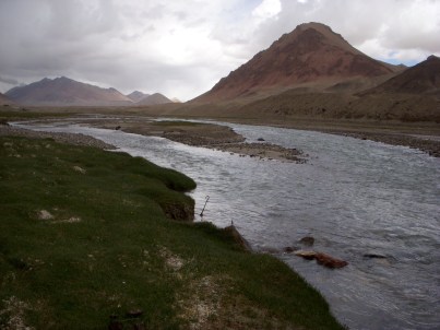
Murghab River, Gordo-Badakshan, Tajikistan
This work included Ar/Ar thermochronometry and U-Pb geochronology in river sediment to constrain the exhumation history of the Pamir mountains, which lie northwest of the Himalaya. Major tectonic terranes in the Pamir also correlate to terranes in Tibet, which provides some insight into the tectonic history of the region (Lukens et al., 2012; Tectonics).
